Evaluating Spatio-Temporal Decline to Agriculture through Satellite Imagery from 2010-2022
Keywords:
Spatio-Temporal, Decline to Agriculture, Satellite ImageryAbstract
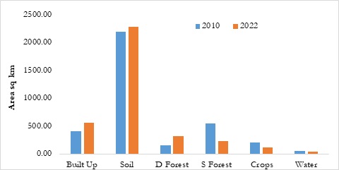
The failure of Pakistani cities to adopt a vertical expansion strategy has led to the encroachment of urban areas onto farmland and pastures. Agricultural land is constantly being lost as cities expand, putting stress on farmers and lowering agricultural productivity. The agricultural industry of Pakistan is vital to the country's economy. It employs 42.3% of the working population and contributes 18.9% to GDP. In addition to bringing in much-needed foreign currency, it helps other areas of the economy flourish as well. Mapping of LULC change is an essential strategy for assessing, managing, and protecting a region's natural resources, and information on present land use is one of the most critical prerequisites for supporting better use of terrain. The examination of LULC variations at all scales—watershed, catchment, and basin—can benefit greatly from the use of remote sensing and Geographical Information system (GIS). The synoptic view and multi-temporal LULC data that can be gathered with remote sensing are valuable. This research determines the spatial and temporal dynamics of change in the Jehlum watershed, an area that has seen significant shifts in its LULC as a result of human and environmental activity. During the course of time, from 2010 to 2022, the study region saw significant changes in the spatial extent of forest cover (8640.239 to 6756.592 ha), horticulture (6891.458 to 8519.483 ha), built-up (858.91 to 2830.438 ha), and agricultural (19483.05 to 18060.83 ha). Changes in LULC over time in the watershed have been linked to deforestation, population growth, and urbanization.


