Conversion of Fertile Agricultural Land into Built-Up by Estimation of Pixel Based Land Surface Temperature (LST)
Keywords:
Remote sensing, Satellite imagery, Spatiotemporal WatershedAbstract
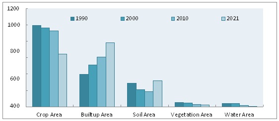
The focus of this study is on how changes in Lahore's land use and land cover have affected the city's average land surface temperature (LST). The area under investigation is a rapidly expanding city in Pakistan, where construction on new buildings and surrounding areas has increased considerably during the past three decades. LANDSAT-5 (TM) and LANDSAT-8 (OLI) satellite images are used to determine land surface temperature and the spatial extent of various land surface features in order to analyze the impact of densely forested areas and expanding urban areas on land surface temperature (LST). In order to determine how much space is taken up by different types of terrain, they are imported into ERDAS imagine-14 and put through a supervised categorization procedure. The land surface temperature (LST) is employed as a dependent variable in this study, with the agricultural area (crop area plus vegetation area) and the built-up area serving as independent factors. Whether or not Lahore's urban growth is displacing farmland over time can be determined with the help of the Persistence Matrix, a geographic information system (GIS) analysis. The two variables under consideration here were both held constant, albeit at atypical amounts. The ARDL model is used to examine the relationship between the dependent variable LST and the independent variables agricultural area and built-up area, and the ECM is used to evaluate the long run and short run cointegration of these three variables. As shown by the persistence matrix, urbanization increased by 325.14 km2 while agricultural land decreased by 300.2 km2 over the study period (sum of crop area and vegetative area). Data like this demonstrates that over the study's time frame, urbanization accelerated alongside the abandonment of farmland. The results of the ARDL model indicate that rapid urbanization in Lahore is positively correlated with LST, while the opposite is true of the association between cultivated area and LST (LST). ECM results also support the presence of long run and short run co integration between the dependent variable and the group of independent variables. Time series data from 1990 to 2021 are used to draw these results


